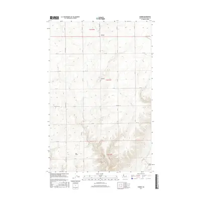
2017 Map of Farmer
USGS Topo · Published 2017About this map
Farmer serves as the central point of reference in this corner of Douglas County, where the agricultural grid meets the dramatic natural breaks of the Big Bend country. The landscape is defined by the transition from high plateau wheat fields to the deep recession of Pegg Canyon and the edge of Moses Coulee in the southeast. This 2017 topographic record illustrates the persistent geometry of rural land division, with roads like W Baseline Rd and Armstrong Rd Sw following township lines established over a century ago. A primary point of interest for genealogists and local historians is the Evangelical Emanuel Cem, located centrally between the deep coulees and the plateau's edge. The network of named routes, including Alstown Cutoff Rd and Basel Rd, reveals the legacy of early homesteading and the logistical routes used to move harvests across this high desert terrain.
Find a feature on this map
28 named features on this map. Tap any name to fly to it.
Don’t see what you’re looking for? This feature index may not catch every label — zoom into the map to look around manually.
Map Details
Editions of this 2017 Farmer Map
This is the sole edition of this map. No revisions or reprints were ever made.
Other maps of this area

1953 · Ritzville
USGS Topo · 1:250,000

1956 · Ephrata
USGS Topo · 1:62,500

1959 · Ritzville
USGS Topo · 1:250,000

1965 · Ritzville
USGS Topo · 1:250,000

1965 · Jameson Lake SW
USGS Topo · 1:24,000

1965 · Jameson Lake West
USGS Topo · 1:24,000
1966 · Palisades
USGS Topo · 1:24,000
1966 · Rattlesnake Springs
USGS Topo · 1:24,000

1968 · Withrow
USGS Topo · 1:24,000

1968 · Lamoine
USGS Topo · 1:24,000