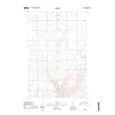
2020 Map of Farmer
USGS Topo · Published 2020About this map
Farmer serves as the central point of reference in this Douglas County landscape, situated along W Baseline Rd. The area is defined by a grid of rural roads that facilitate movement across the terrain, including Armstrong Rd Sw and Alstown Cutoff Rd. A notable landmark for local historians and genealogists is the Evangelical Emanuel Cem, located south of the main settlement. The map reveals a structured land pattern typical of the region, where roads like Basel Rd and Armstrong E Rd divide the territory into sections. The topography is marked by significant elevation changes, with contours illustrating the varied relief that characterizes this part of Washington. This survey provides a clear look at the spatial relationship between the small community and the surrounding agricultural or open lands at the beginning of the decade.
Find a feature on this map
27 named features on this map. Tap any name to fly to it.
Don’t see what you’re looking for? This feature index may not catch every label — zoom into the map to look around manually.
Map Details
Editions of this 2020 Farmer Map
This is the sole edition of this map. No revisions or reprints were ever made.
Other maps of this area

1953 · Ritzville
USGS Topo · 1:250,000

1956 · Ephrata
USGS Topo · 1:62,500

1959 · Ritzville
USGS Topo · 1:250,000

1965 · Ritzville
USGS Topo · 1:250,000

1965 · Jameson Lake SW
USGS Topo · 1:24,000

1965 · Jameson Lake West
USGS Topo · 1:24,000
1966 · Palisades
USGS Topo · 1:24,000
1966 · Rattlesnake Springs
USGS Topo · 1:24,000

1968 · Withrow
USGS Topo · 1:24,000

1968 · Lamoine
USGS Topo · 1:24,000