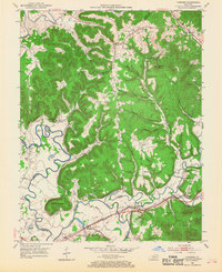
1953 Map of Farmers
USGS Topo · Published 1968About this map
The Licking River winds through the Kentucky landscape of Rowan, Bath, and Fleming Counties, defining a region where river bends like Ingram Bend and Muleshoe Bend shaped early movement. Along the southern edge, the Chesapeake and Ohio railroad corridor anchors the settlements of Farmers, Midland, and Bluestone, reflecting the importance of rail transport to the local economy in the early 1950s. The interior terrain is marked by numerous family-named landmarks and community centers, such as Moore Sch and Poplar Spring Ch. Local history and genealogy are preserved in the locations of the Jones Cem, Ethridge Cem, and Markwell Cem. The map also captures infrastructure from a bygone era, including Moores Ferry and Moores Ford, providing evidence of historical river crossings before modern bridges dominated the corridor.
Find a feature on this map
55 named features on this map. Tap any name to fly to it.
Don’t see what you’re looking for? This feature index may not catch every label — zoom into the map to look around manually.
Map Details
Editions of this 1953 Farmers Map
2 editions found
Other maps of this area

1929 · Morehead
USGS Topo · 1:48,000

1929 · Salt Lick
USGS Topo · 1:62,500

1934 · Salt Lick
USGS Topo · 1:62,500

1935 · Morehead
USGS Topo · 1:62,500

1951 · Cranston
USGS Topo · 1:24,000

1951 · Hillsboro
USGS Topo · 1:24,000

1951 · Plummers Landing
USGS Topo · 1:24,000

1953 · Olympia
USGS Topo · 1:24,000

1953 · Farmers
USGS Topo · 1:24,000

1953 · Bangor
USGS Topo · 1:24,000