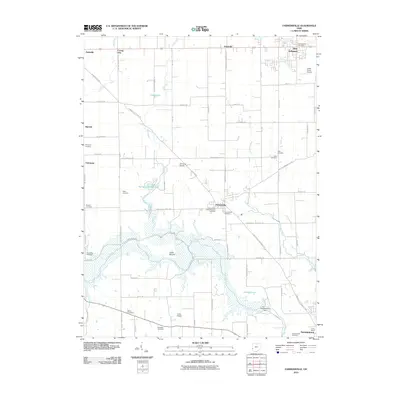
2010 Map of Farmersville
USGS Topo · Published 2010About this map
Farmersville and its surrounding rural townships are centered in this modern topographic study, showing a landscape defined by its agricultural grid and the winding course of Twin Creek. The topography is notably influenced by the Germantown Dam and the flood control measures in the south, where the creek meanders past Cedar Mound and Sunfish Pond. This area on the County Line between Montgomery and Preble counties reveals a dense concentration of historical burial grounds, including the Dutch Cemetery, Twin Valley Cemetery, and Slifer Cemetery, providing a wealth of information for those tracing regional family history.
Find a feature on this map
78 named features on this map. Tap any name to fly to it.
Don’t see what you’re looking for? This feature index may not catch every label — zoom into the map to look around manually.
Map Details
Editions of this 2010 Farmersville Map
This is the sole edition of this map. No revisions or reprints were ever made.
Other maps of this area

1905 · Brookville
USGS Topo · 1:62,500

1908 · Miamisburg
USGS Topo · 1:62,500

1911 · Oxford
USGS Topo · 1:62,500

1951 · Franklin
USGS Topo · 1:24,000

1953 · Cincinnati
USGS Topo · 1:250,000

1955 · Miamisburg
USGS Topo · 1:24,000
1955 · Trotwood
USGS Topo · 1:24,000

1957 · Cincinnati
USGS Topo · 1:250,000
1959 · Middletown
USGS Topo · 1:24,000

1960 · Farmersville
USGS Topo · 1:24,000