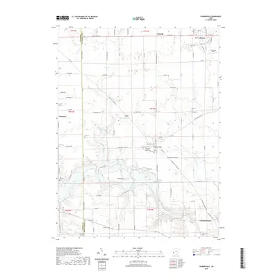
2019 Map of Farmersville
USGS Topo · Published 2019About this map
The boundary between Preble Co and Montgomery Co runs vertically through this map, separating a landscape of agricultural tracts and small aviation fields. Farmersville sits near the center, serving as a hub for local roads like the Farmersville Gratis Rd and Farmersville Germanth Rd. To the south, the terrain descends toward Germantown and the winding course of Twin Creek, which is joined by tributaries such as Toms Run and Little Twin Creek.
Find a feature on this map
109 named features on this map. Tap any name to fly to it.
Don’t see what you’re looking for? This feature index may not catch every label — zoom into the map to look around manually.
Map Details
Editions of this 2019 Farmersville Map
This is the sole edition of this map. No revisions or reprints were ever made.
Other maps of this area

1905 · Brookville
USGS Topo · 1:62,500

1908 · Miamisburg
USGS Topo · 1:62,500

1911 · Oxford
USGS Topo · 1:62,500

1951 · Franklin
USGS Topo · 1:24,000

1953 · Cincinnati
USGS Topo · 1:250,000

1955 · Miamisburg
USGS Topo · 1:24,000
1955 · Trotwood
USGS Topo · 1:24,000

1957 · Cincinnati
USGS Topo · 1:250,000
1959 · Middletown
USGS Topo · 1:24,000

1960 · Farmersville
USGS Topo · 1:24,000