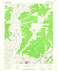
1963 Map of Farmington North
USGS Topo · Published 1965About this map
Animas River and La Plata River converge just south of this 1963 survey, which documents the northward expansion of Farmington. The northern residential districts are defined by a trio of education facilities, including Hermosa Jr High Sch, Ladera del Norte Sch, and Mesa Verde Sch, alongside the Bethany Ch. This era shows a community growing rapidly into the surrounding desert geography, where the irrigation potential of the river valleys meets the higher elevations of Hood Mesa and Piñon Mesa.
Find a feature on this map
43 named features on this map. Tap any name to fly to it.
Don’t see what you’re looking for? This feature index may not catch every label — zoom into the map to look around manually.
Map Details
Editions of this 1963 Farmington North Map
2 editions found
Other maps of this area

1889 · Chaco
USGS Topo · 1:250,000

1892 · Chaco
USGS Topo · 1:250,000

1927 · Sulphur Spring
USGS Topo · 1:96,000

1928 · Kirtland
USGS Topo · 1:125,000

1932 · Kirtland
USGS Topo · 1:125,000

1954 · Shiprock
USGS Topo · 1:250,000

1958 · Shiprock
USGS Topo · 1:250,000

1959 · Shiprock
USGS Topo · 1:250,000
1963 · La Plata
USGS Topo · 1:24,000
1963 · Flora Vista
USGS Topo · 1:24,000