1963 Map of Flora Vista
USGS Topo · Published 1965About this map
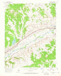
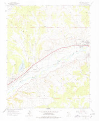
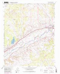
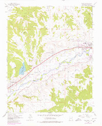
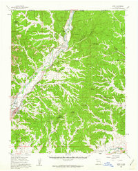
The Animas River valley serves as the central artery for this 1963 survey, where a complex network of irrigation channels like Farmers Ditch, Independent Ditch, and the Rio Grande and Western Ditch support agriculture along the fertile corridor. The landscape is a study in transition, moving from the industrial outskirts of Farmington in the southwest to the historic core of Aztec in the northeast. The presence of the Denver and Rio Grande Western railroad corridor and the Elledge Mill underscores the region's mid-century economic character. Local heritage is deeply rooted in this terrain, visible through landmarks such as the Aztec Ruins and community spaces like the Flora Vista Cem. Beyond the river, the geography rises into Bald Mesa, marked by numerous arroyos and water management features including the Beeline Reservoir and Flora Vista Reservoir.
Find a feature on this map
45 named features on this map. Tap any name to fly to it.
Don’t see what you’re looking for? This feature index may not catch every label — zoom into the map to look around manually.
Map Details
Editions of this 1963 Flora Vista Map
4 editions found
Other maps of this area

1889 · Largo
USGS Topo · 1:250,000

1889 · Chaco
USGS Topo · 1:250,000

1892 · Chaco
USGS Topo · 1:250,000

1895 · Largo
USGS Topo · 1:250,000

1954 · Shiprock
USGS Topo · 1:250,000

1954 · Aztec
USGS Topo · 1:250,000

1958 · Shiprock
USGS Topo · 1:250,000

1958 · Aztec
USGS Topo · 1:250,000

1959 · Shiprock
USGS Topo · 1:250,000
1959 · Aztec
USGS Topo · 1:62,500