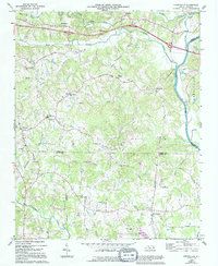
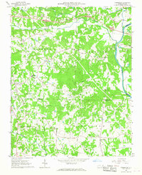
1966 Map of Farmington
USGS Topo · Published 1994About this map
The Yadkin River defines the eastern edge of this Piedmont landscape, carving a boundary between Yadkin, Forsyth, and Davie Counties. During the mid-1960s, the rural character of this region was anchored by several small communities and an extensive network of country roads. The settlement of Farmington serves as a southern hub, while the northern reaches are marked by Shacktown and the Deep Creek Community Center. This survey provides a detailed look at the local spiritual and educational geography, featuring landmarks such as the Huntsville Tabernacle, Wesley Chapel, and the Courtney High Sch.
Find a feature on this map
46 named features on this map. Tap any name to fly to it.
Don’t see what you’re looking for? This feature index may not catch every label — zoom into the map to look around manually.
Map Details
Editions of this 1966 Farmington Map
2 editions found
Other maps of this area

1891 · Yadkinville
USGS Topo · 1:125,000

1893 · Statesville
USGS Topo · 1:125,000

1893 · Yadkinville
USGS Topo · 1:125,000

1953 · Charlotte
USGS Topo · 1:250,000

1953 · Winston-Salem
USGS Topo · 1:250,000

1954 · Charlotte
USGS Topo · 1:250,000

1955 · Winston-Salem
USGS Topo · 1:250,000

1960 · Charlotte
USGS Topo · 1:250,000

1962 · Winston-Salem
USGS Topo · 1:250,000

1962 · Charlotte
USGS Topo · 1:250,000