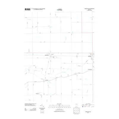
2013 Map of Farmland
USGS Topo · Published 2013About this map
Farmland and Parker City sit along the primary east-west rail and road corridor in this portion of Randolph County, illustrating the enduring layout of rural Indiana's small-town hubs. The White River and its tributary, the Little White River, meander across the southern half of the landscape, defining the drainage patterns that shaped early settlement near Windsor. Further north, a network of agricultural drainage channels like Carmichael Ditch and Lamb Ditch support the surrounding fields, while the Belknap-Icarus Acres Airport provides a localized aviation landmark. Small clusters of habitation at Georgetown and the many numbered county roads reveal a transition from traditional river-oriented settlements to a grid-based agricultural economy, offering a clear view of the regional infrastructure as it stood in the early 21st century.
Find a feature on this map
88 named features on this map. Tap any name to fly to it.
Don’t see what you’re looking for? This feature index may not catch every label — zoom into the map to look around manually.
Map Details
Editions of this 2013 Farmland Map
This is the sole edition of this map. No revisions or reprints were ever made.
Other maps of this area

1952 · Maxville
USGS Topo · 1:24,000

1952 · Muncie East
USGS Topo · 1:24,000

1952 · Farmland
USGS Topo · 1:24,000

1953 · Muncie
USGS Topo · 1:250,000

1956 · Muncie
USGS Topo · 1:250,000

1960 · Eaton
USGS Topo · 1:24,000

1960 · Mount Pleasant
USGS Topo · 1:24,000

1960 · Carlos
USGS Topo · 1:24,000

1960 · Ridgeville
USGS Topo · 1:24,000
1960 · Modoc
USGS Topo · 1:24,000