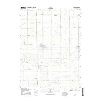
2016 Map of Farmland
USGS Topo · Published 2016About this map
Parker City and the town of Farmland anchor this rural landscape along the border of Delaware and Randolph counties. This 2016 survey highlights a structured grid of county roads and residential streets, such as E Jackson St and S Main St, that connect these historic agricultural hubs. The White River winds through the central portion of the sheet, joined by a network of local waterways including Cabin Cr, Stoney Creek, and the Little White River. Genealogists will find notable burial sites such as Freidline Cem near the western edge and Swingley Cem further south. The presence of Windsor and Georgetown indicates smaller clusters of settlement that have persisted alongside the drainage systems of Elkhorn Cr and Lamb Ditch. Aviation interests are represented by the Belknap-Icarus Acres Airport, located just north of the county line.
Find a feature on this map
100 named features on this map. Tap any name to fly to it.
Don’t see what you’re looking for? This feature index may not catch every label — zoom into the map to look around manually.
Map Details
Editions of this 2016 Farmland Map
This is the sole edition of this map. No revisions or reprints were ever made.
Other maps of this area

1952 · Maxville
USGS Topo · 1:24,000

1952 · Muncie East
USGS Topo · 1:24,000

1952 · Farmland
USGS Topo · 1:24,000

1953 · Muncie
USGS Topo · 1:250,000

1956 · Muncie
USGS Topo · 1:250,000

1960 · Eaton
USGS Topo · 1:24,000

1960 · Mount Pleasant
USGS Topo · 1:24,000

1960 · Carlos
USGS Topo · 1:24,000

1960 · Ridgeville
USGS Topo · 1:24,000
1960 · Modoc
USGS Topo · 1:24,000