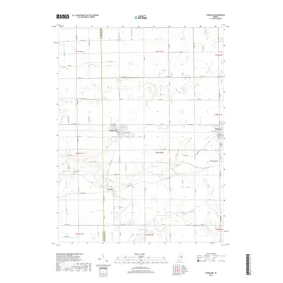
2019 Map of Farmland
USGS Topo · Published 2019About this map
Farmland and Parker City serve as the primary hubs in this agricultural landscape straddling the Delaware and Randolph County line. The terrain is defined by the headwaters and meandering courses of the White River and the Little White River, which are fed by numerous small tributaries like Stoney Creek and Cabin Creek. This network of waterways influenced the early placement of rural settlements and cemeteries, which are scattered throughout the township grids.
Find a feature on this map
96 named features on this map. Tap any name to fly to it.
Don’t see what you’re looking for? This feature index may not catch every label — zoom into the map to look around manually.
Map Details
Editions of this 2019 Farmland Map
This is the sole edition of this map. No revisions or reprints were ever made.
Other maps of this area

1952 · Maxville
USGS Topo · 1:24,000

1952 · Muncie East
USGS Topo · 1:24,000

1952 · Farmland
USGS Topo · 1:24,000

1953 · Muncie
USGS Topo · 1:250,000

1956 · Muncie
USGS Topo · 1:250,000

1960 · Eaton
USGS Topo · 1:24,000

1960 · Mount Pleasant
USGS Topo · 1:24,000

1960 · Carlos
USGS Topo · 1:24,000

1960 · Ridgeville
USGS Topo · 1:24,000
1960 · Modoc
USGS Topo · 1:24,000