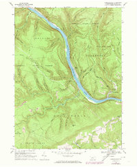
1966 Map of Farrandsville
USGS Topo · Published 1973About this map
The West Branch Susquehanna River carves a deep valley through this mid-1960s Pennsylvania landscape, serving as the primary corridor for both industry and transport. The Penn Central railroad follows the river's winding course, connecting small riverside settlements like Farrandsville and Ferney. The upland areas are dominated by extensive public lands, including Sproul State Forest and State Game Lands No 89, where the terrain is marked by numerous hollows and runs such as Buckhorn Hollow and Lick Run.
Find a feature on this map
47 named features on this map. Tap any name to fly to it.
Don’t see what you’re looking for? This feature index may not catch every label — zoom into the map to look around manually.
Map Details
Editions of this 1966 Farrandsville Map
2 editions found
Other maps of this area

1921 · Howard
USGS Topo · 1:48,000

1921 · Lock Haven
USGS Topo · 1:62,500

1923 · Howard
USGS Topo · 1:62,500

1923 · Lock Haven
USGS Topo · 1:62,500

1937 · Waterville
USGS Topo · 1:48,000

1943 · Hyner
USGS Topo · 1:62,500

1943 · Waterville
USGS Topo · 1:62,500

1944 · Lock Haven
USGS Topo · 1:62,500

1946 · Renovo East
USGS Topo · 1:62,500

1946 · Renovo East
USGS Topo · 1:24,000
Featured Places
- Beech Creek Township, PA
- Bald Eagle Township, PA
- Grugan Township, PA
- Riverview, Bald Eagle Township
- East Ferney, Colebrook Township