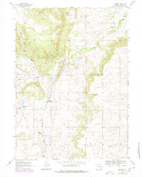
1962 Map of Farthing
USGS Topo · Published 1978About this map
Farthing (Iron Mountain PO) serves as the focal point for this high-plains landscape, where the Colorado and Southern railroad tracks follow the winding course of Sand Creek. The settlement pattern is defined by established family holdings like Whiting Ranch and McLees Ranch, illustrating the ranching-driven economy of Laramie County during the mid-20th century. The intricate drainage network of Chugwater Creek and its many tributaries, including Middle Chugwater Cr and South Chugwater Creek, carves through the terrain near the prominent elevation of Pine Top. This 1962 topography, updated in the late 1970s, captures a transition in water management at the Farthing Reservoir and the essential rail connection that linked these remote ranching outposts to larger markets.
Find a feature on this map
20 named features on this map. Tap any name to fly to it.
Don’t see what you’re looking for? This feature index may not catch every label — zoom into the map to look around manually.
Map Details
Editions of this 1962 Farthing Map
2 editions found
Other maps of this area

1905 · Sherman
USGS Topo · 1:125,000

1948 · Ragged Top Mountain
USGS Topo · 1:62,500

1950 · Ragged Top Mountain
USGS Topo · 1:62,500

1954 · Cheyenne
USGS Topo · 1:250,000

1955 · Indian Guide
USGS Topo · 1:24,000

1955 · Goat Mountain
USGS Topo · 1:24,000

1958 · Cheyenne
USGS Topo · 1:250,000

1962 · Horse Creek
USGS Topo · 1:24,000

1962 · Dereemer Ranch
USGS Topo · 1:24,000

1962 · Farthing
USGS Topo · 1:24,000