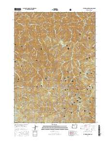
2017 Map of Father Mountain
USGS Topo · Published 2017About this map
Siskiyou National Forest dominates this section of Curry County, where the steep Pacific Coast Range rises abruptly from the drainages of the Elk River and Panther Cr. This modern survey reveals a complex network of forest development roads, including Nat For Dev Rd 5544 and Nat For Dev Rd 180, providing access to the dense timberlands and summits. Several prominent peaks, such as Father Mtn, Milbury Mtn, and Anvil Mtn, serve as high-ground anchors for the surrounding watershed. The drainage patterns are intricate, with numerous named waterways like Mussel Cr and Euchre Cr cutting through the terrain. Geographers can observe the intersection of traditional land survey townships, such as t33s r14w, with the managed wilderness. Notable landmarks like Salal Spring and Chismore Butte provide specific points of reference within the continuous forest canopy.
Find a feature on this map
48 named features on this map. Tap any name to fly to it.
Don’t see what you’re looking for? This feature index may not catch every label — zoom into the map to look around manually.
Map Details
Editions of this 2017 Father Mountain Map
This is the sole edition of this map. No revisions or reprints were ever made.
Other maps of this area

1899 · Port Orford
USGS Topo · 1:125,000

1903 · Port Orford
USGS Topo · 1:125,000

1954 · Coos Bay
USGS Topo · 1:250,000

1954 · Port Orford
USGS Topo · 1:62,500

1954 · Agness
USGS Topo · 1:62,500

1954 · Powers
USGS Topo · 1:62,500

1954 · Langlois
USGS Topo · 1:62,500

1958 · Coos Bay
USGS Topo · 1:250,000

1962 · Coos Bay
USGS Topo · 1:250,000
1986 · Father Mountain
USGS Topo · 1:24,000