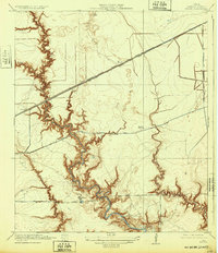
1932 Map of Fauna
USGS Topo · Published 1932About this map
Greens Bayou and Halls Bayou snake through this landscape east of Houston, their deep meanders cutting through the prairie floor before the onset of modern suburban expansion. The era's transit network is defined by the Southern Pacific System (Texas and New Orleans Road), which bisects the region near the small settlement of Fauna. Local commerce and travel center on historic thoroughfares such as Market Street Road and the Houston and Wallisville Road. At Abbots Store, located along the southern edge of the survey, a window into early 20th-century rural life is preserved, showing the importance of small crossroads outposts. The intricate drainage patterns of Big Gulch and Spring Gulch illustrate a hydrologically complex environment adjacent to Round Prairie, providing a detailed record of the natural topography before later drainage and development altered the watershed.
Find a feature on this map
13 named features on this map. Tap any name to fly to it.
Don’t see what you’re looking for? This feature index may not catch every label — zoom into the map to look around manually.
Map Details
Editions of this 1932 Fauna Map
This is the sole edition of this map. No revisions or reprints were ever made.
Other maps of this area

1915 · Park Place
USGS Topo · 1:24,000

1915 · Deepwater
USGS Topo · 1:24,000

1916 · Burnett Bay
USGS Topo · 1:24,000

1916 · Crosby
USGS Topo · 1:24,000

1916 · Settegast
USGS Topo · 1:24,000

1916 · Fauna
USGS Topo · 1:24,000

1916 · Harmaston
USGS Topo · 1:24,000

1916 · Humble
USGS Topo · 1:24,000

1916 · La Porte
USGS Topo · 1:24,000

1919 · Deepwater
USGS Topo · 1:31,680