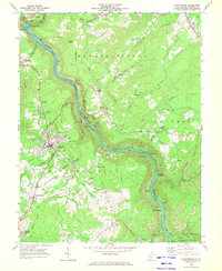
1969 Map of Fayetteville
USGS Topo · Published 1972About this map
The New River gorge dominates this 1969 landscape, carving a deep path through the coal-rich plateaus of Fayette County. Along its steep banks, the infrastructure of the region's industrial backbone is clearly visible, with the Chesapeake and Ohio railroad following the water’s edge to serve coal-loading sites like Kaymoor No 1 and Nuttall Station. The map illustrates the vertical nature of life in the gorge, where tramways, conveyors, and tipples connected mines on the canyon walls to the transport lines below.
Find a feature on this map
79 named features on this map. Tap any name to fly to it.
Don’t see what you’re looking for? This feature index may not catch every label — zoom into the map to look around manually.
Map Details
Editions of this 1969 Fayetteville Map
3 editions found
Other maps of this area

1887 · Hinton
USGS Topo · 1:125,000

1889 · Nicholas
USGS Topo · 1:125,000

1891 · Nicholas
USGS Topo · 1:125,000

1891 · Raleigh
USGS Topo · 1:125,000

1892 · Hinton
USGS Topo · 1:125,000

1897 · Kanawha Falls
USGS Topo · 1:125,000

1897 · Raleigh
USGS Topo · 1:125,000

1900 · Kanawha Falls
USGS Topo · 1:125,000

1901 · Nicholas
USGS Topo · 1:125,000

1901 · Kanawha Falls
USGS Topo · 1:125,000