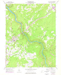
1969 Map of Fayetteville
USGS Topo · Published 1977About this map
New River gorge coal and rail operations define this landscape, where steep canyon walls separate the upland plateau communities from industrial riverside settlements. Along the water, the Chesapeake and Ohio River railroad services steep-grade mining hubs like Kaymoor, Nuttall Station, and Caperton. These sites, connected to the rim by a complex network of conveyors, tipples, and a tramway at Lansing, illustrate the era's intensive extraction economy. On the higher ground, the county seat of Fayetteville serves as the regional center, surrounded by family and community landmarks such as Pierce Cem and Huse Memorial Cem. The map further captures the local transition to recreation and conservation at Hawks Nest State Park and the edges of Babcock State Park, documenting a region balancing industrial utility with burgeoning parklands.
Find a feature on this map
82 named features on this map. Tap any name to fly to it.
Don’t see what you’re looking for? This feature index may not catch every label — zoom into the map to look around manually.
Map Details
Editions of this 1969 Fayetteville Map
3 editions found
Other maps of this area

1887 · Hinton
USGS Topo · 1:125,000

1889 · Nicholas
USGS Topo · 1:125,000

1891 · Nicholas
USGS Topo · 1:125,000

1891 · Raleigh
USGS Topo · 1:125,000

1892 · Hinton
USGS Topo · 1:125,000

1897 · Kanawha Falls
USGS Topo · 1:125,000

1897 · Raleigh
USGS Topo · 1:125,000

1900 · Kanawha Falls
USGS Topo · 1:125,000

1901 · Nicholas
USGS Topo · 1:125,000

1901 · Kanawha Falls
USGS Topo · 1:125,000