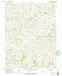
1963 Map of Fayetteville
USGS Topo · Published 1964About this map
The settlement of Fayetteville sits near the southern boundary of the Lafayette Co Johnson Co line, serving as a focal point for this rural landscape in the early 1960s. The area is defined by its agricultural and pastoral character, where small clusters of civic life like Robbins are connected by a network of creeks. Waterways such as Davis Creek in the north and Honey Creek in the south carve through the terrain, influencing the placement of local landmarks.
Find a feature on this map
19 named features on this map. Tap any name to fly to it.
Don’t see what you’re looking for? This feature index may not catch every label — zoom into the map to look around manually.
Map Details
Editions of this 1963 Fayetteville Map
2 editions found
Other maps of this area

1885 · Warrensburg
USGS Topo · 1:125,000

1887 · Warrensburg
USGS Topo · 1:125,000

1889 · Lexington
USGS Topo · 1:125,000

1894 · Warrensburg
USGS Topo · 1:125,000

1917 · Knobnoster
USGS Topo · 1:62,500

1947 · Jefferson City
USGS Topo · 1:250,000

1949 · Mayview
USGS Topo · 1:24,000

1949 · Odessa North
USGS Topo · 1:24,000

1950 · Mayview
USGS Topo · 1:24,000

1950 · Odessa North
USGS Topo · 1:24,000