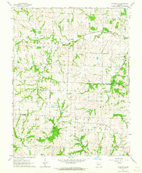
1963 Map of Fayetteville
USGS Topo · Published 1964About this map
Davis Creek and its southern branch wind through the rural landscape of Lafayette and Johnson counties, defining a region dominated by small agricultural settlements and dispersed community landmarks. The small hamlet of Fayetteville sits in the southeast corner near the banks of Crooked Creek, while Robbins marks a central point along the local road network. This early 1960s survey illustrates a deeply rooted social geography, where rural life centered on institutions like Wallace Chapel, Cedar Grove Ch, and Long Branch Ch. Several Quarry sites are noted across the terrain, indicating the importance of local stone extraction alongside traditional farming. The map also records the location of the Farmers Sch, a vestige of the era's local educational system before widespread consolidation, and identifies the township boundaries of Davis, Washington, and Hazel Hill.
Find a feature on this map
19 named features on this map. Tap any name to fly to it.
Don’t see what you’re looking for? This feature index may not catch every label — zoom into the map to look around manually.
Map Details
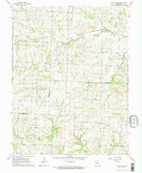
Editions of this 1963 Fayetteville Map
2 editions found
Other maps of this area

1885 · Warrensburg
USGS Topo · 1:125,000

1887 · Warrensburg
USGS Topo · 1:125,000

1889 · Lexington
USGS Topo · 1:125,000

1894 · Warrensburg
USGS Topo · 1:125,000

1917 · Knobnoster
USGS Topo · 1:62,500

1947 · Jefferson City
USGS Topo · 1:250,000

1949 · Mayview
USGS Topo · 1:24,000

1949 · Odessa North
USGS Topo · 1:24,000

1950 · Mayview
USGS Topo · 1:24,000

1950 · Odessa North
USGS Topo · 1:24,000