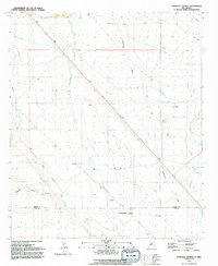
1992 Map of Faywood Station
USGS Topo · Published 1992About this map
Faywood Station sits at the southern edge of this landscape, marking a point of transition in the high desert terrain near the border of Grant and Luna counties. The map reveals a land defined by ephemeral water management and mining-related infrastructure, most notably the large Tailings Pond and associated Aqueduct in the northern reaches. These features, along with a Pumping Station and multiple Water Tanks, suggest a landscape heavily modified for resource extraction and industrial processing. Natural drainage patterns like the Whitewater Creek and the wide San Vicente Arroyo cut through the arid flats, while the Hogback provides a distinct topographical break in the southwestern corner. The network of unimproved roads and survey marks underscores the utilitarian nature of the area in the early 1990s.
Find a feature on this map
12 named features on this map. Tap any name to fly to it.
Don’t see what you’re looking for? This feature index may not catch every label — zoom into the map to look around manually.
Map Details
Editions of this 1992 Faywood Station Map
This is the sole edition of this map. No revisions or reprints were ever made.
Other maps of this area

1899 · Deming
USGS Topo · 1:125,000

1909 · Silver City
USGS Topo · 1:125,000

1915 · Deming
USGS Topo · 1:125,000

1947 · Faywood Station
USGS Topo · 1:24,000

1948 · Hurley East
USGS Topo · 1:24,000

1949 · Whitewater
USGS Topo · 1:24,000

1949 · Hurley East
USGS Topo · 1:24,000

1949 · Faywood Station
USGS Topo · 1:24,000

1949 · Hurley West
USGS Topo · 1:24,000

1954 · Silver City
USGS Topo · 1:250,000