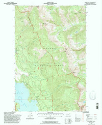
1994 Map of Felix Peak
USGS Topo · Published 1997About this map
Hungry Horse Reservoir and the South Fork Flathead River dominate the western edge of this landscape, reflecting a region managed for both resource extraction and wilderness preservation in the mid-1990s. The terrain transitions from the shoreline at the Boat Landing and Betty Creek Work Station up into the high-elevation peaks of the Flathead National Forest. This area is defined by its drainage network, with Felix Creek, Unawah Creek, and Logan Creek carving through the mountains. Human activity is sparse but visible through specialized infrastructure like the Baptiste Lookout and the Felix Mine, located near Felix Peak. The inclusion of the Great Bear Wilderness Bdy underscores the protected nature of the eastern heights, where Dryface Trail offers one of the few established routes across the high basins and ridges.
Find a feature on this map
33 named features on this map. Tap any name to fly to it.
Don’t see what you’re looking for? This feature index may not catch every label — zoom into the map to look around manually.
Map Details
Editions of this 1994 Felix Peak Map
This is the sole edition of this map. No revisions or reprints were ever made.
Other maps of this area

1914 · Nyack
USGS Topo · 1:125,000

1958 · Circus Peak
USGS Topo · 1:24,000

1958 · Nimrod
USGS Topo · 1:24,000

1958 · Quintonkon
USGS Topo · 1:24,000

1958 · Felix Peak
USGS Topo · 1:24,000

1960 · Cut Bank
USGS Topo · 1:250,000

1963 · Cut Bank
USGS Topo · 1:250,000

1964 · Cut Bank
USGS Topo · 1:250,000

1964 · Essex
USGS Topo · 1:24,000

1964 · Pinnacle
USGS Topo · 1:24,000