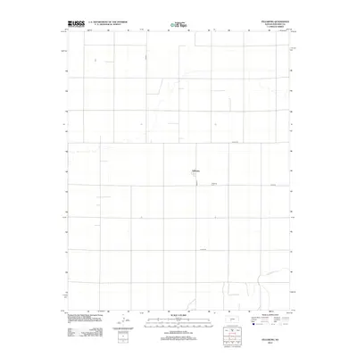
2012 Map of Fellsburg
USGS Topo · Published 2012About this map
Fellsburg sits at the center of this Edwards County landscape, defined by the organized grid of agricultural roads and the meandering path of Rattlesnake Cr. The terrain reflects the classic settlement pattern of the Kansas plains, where small community hubs developed around vital local institutions like the Fellsburg Cem south of the main townsite. This 2012 survey documents the enduring infrastructure of the region, including the intersection of Co Rd-45 and Co Hwy-36, which serves as a primary artery for the surrounding rural homesteads. The sparse distribution of named features underscores the vast, open nature of the prairie as it appeared in the early 21st century.
Find a feature on this map
8 named features on this map. Tap any name to fly to it.
Don’t see what you’re looking for? This feature index may not catch every label — zoom into the map to look around manually.
Map Details
Editions of this 2012 Fellsburg Map
This is the sole edition of this map. No revisions or reprints were ever made.
Other maps of this area

1889 · Kinsley
USGS Topo · 1:125,000

1892 · Kinsley
USGS Topo · 1:125,000

1894 · Kinsley
USGS Topo · 1:125,000

1955 · Pratt
USGS Topo · 1:250,000

1959 · Pratt
USGS Topo · 1:250,000

1968 · Haviland NW
USGS Topo · 1:24,000

1968 · Haviland NE
USGS Topo · 1:24,000
1969 · Greensburg NE
USGS Topo · 1:24,000
1971 · Trousdale
USGS Topo · 1:24,000
1972 · Belpre
USGS Topo · 1:24,000