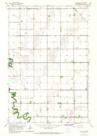
1966 Map of Felton SW
USGS Topo · Published 1967About this map
The Buffalo River winds sharply through the western half of this Clay County landscape, defining the topography of the Kragnes and Georgetown townships during the mid-1960s. This survey illustrates a highly managed agricultural environment where the natural drainage of the river is supplemented by an extensive network of drainage infrastructure, including County Ditch No 14, County Ditch No 6, and County Ditch No 45. These man-made channels carve straight lines across the sectioned prairie, supporting the productive farms of Viding and Morken.
Find a feature on this map
16 named features on this map. Tap any name to fly to it.
Don’t see what you’re looking for? This feature index may not catch every label — zoom into the map to look around manually.
Map Details
Editions of this 1966 Felton SW Map
This is the sole edition of this map. No revisions or reprints were ever made.
Other maps of this area

1895 · Fargo
USGS Topo · 1:125,000

1897 · Fargo
USGS Topo · 1:125,000

1952 · Grand Forks
USGS Topo · 1:250,000

1953 · Fargo
USGS Topo · 1:250,000

1956 · Fargo
USGS Topo · 1:250,000

1956 · Grand Forks
USGS Topo · 1:250,000

1959 · Fargo North
USGS Topo · 1:24,000

1963 · Georgetown
USGS Topo · 1:24,000

1963 · Perley
USGS Topo · 1:24,000

1964 · Dilworth
USGS Topo · 1:24,000