
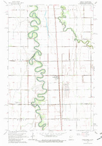
1963 Map of Perley
USGS Topo · Published 1964About this map
The serpentine Red River creates a meandering border between Minnesota and North Dakota, dominating the center of this 1963 survey. The settlement of Perley stands as the primary hub along the Great Northern railroad line, surrounded by the townships of Lee, Hendrum, and Noble. This region of the Red River Valley is defined by its sophisticated drainage network, including County Ditch No 13 and County Ditch No 49, which support the flat agricultural lands of Norman Co. To the south, the Wild Rice River joins the landscape near Kirkebo Cem. Local landmarks such as the Dew Drop In Airport and Nora Ch provide specific points of interest for those researching the social and transit history of this borderland prairie during the early 1960s.
Find a feature on this map
60 named features on this map. Tap any name to fly to it.
Don’t see what you’re looking for? This feature index may not catch every label — zoom into the map to look around manually.
Map Details
Editions of this 1963 Perley Map
2 editions found
Other maps of this area

1918 · Hendrum
USGS Topo · 1:62,500

1924 · Ada
USGS Topo · 1:62,500

1952 · Grand Forks
USGS Topo · 1:250,000

1956 · Grand Forks
USGS Topo · 1:250,000

1963 · Georgetown
USGS Topo · 1:24,000
1963 · Argusville
USGS Topo · 1:24,000

1963 · Gardner
USGS Topo · 1:24,000

1963 · Halstad
USGS Topo · 1:24,000

1963 · Halstad SW
USGS Topo · 1:24,000

1965 · Anthony
USGS Topo · 1:24,000