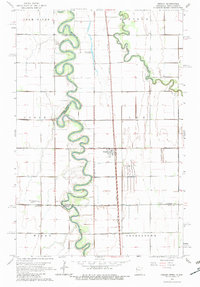
1963 Map of Perley
USGS Topo · Published 1982About this map
The Red River carves a highly sinuous path along the border of North Dakota and Minnesota, defining the western edge of Perley and the surrounding agricultural townships. This 1963 survey illustrates a landscape dominated by the intricate meanders of the Red, Elm River, and Wild Rice River, revealing how natural drainage and man-made improvements like County Ditch No 13 and County Ditch No 49 shaped the fertile Red River Valley. The presence of the Great Northern railroad running parallel to the river highlights the importance of rail transport for moving grain and goods from these remote prairie settlements.
Find a feature on this map
23 named features on this map. Tap any name to fly to it.
Don’t see what you’re looking for? This feature index may not catch every label — zoom into the map to look around manually.
Map Details
Editions of this 1963 Perley Map
2 editions found
Other maps of this area

1918 · Hendrum
USGS Topo · 1:62,500

1924 · Ada
USGS Topo · 1:62,500

1952 · Grand Forks
USGS Topo · 1:250,000

1956 · Grand Forks
USGS Topo · 1:250,000

1963 · Georgetown
USGS Topo · 1:24,000
1963 · Argusville
USGS Topo · 1:24,000

1963 · Perley
USGS Topo · 1:24,000

1963 · Gardner
USGS Topo · 1:24,000

1963 · Halstad
USGS Topo · 1:24,000

1963 · Halstad SW
USGS Topo · 1:24,000