
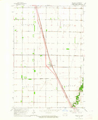
1963 Map of Gardner
USGS Topo · Published 1964About this map
The Great Northern railway forms the backbone of this prairie landscape, running north-south through the settlements of Gardner and Grandin. Located at the boundary of Traill Co Cass Co, the area is defined by its rectilinear section lines and the meandering path of the Elm River in the north. The map documents a period of modern infrastructure expansion, specifically noting the railway as being under construction in certain stretches. Agricultural townships like Kinyon, Noble, Kelso, and Gardner partition the flat terrain, where fine red dashed lines indicate fence and field boundaries visible from aerial photography. This detailed planimetry provides a precise record of the rural Red River Valley landscape as it transitioned in the early 1960s, showing the intersection of long-established township divisions and evolving transportation corridors.
Find a feature on this map
10 named features on this map. Tap any name to fly to it.
Don’t see what you’re looking for? This feature index may not catch every label — zoom into the map to look around manually.
Map Details
Editions of this 1963 Gardner Map
This is the sole edition of this map. No revisions or reprints were ever made.
Other maps of this area

1918 · Kelso
USGS Topo · 1:62,500

1918 · Hendrum
USGS Topo · 1:62,500

1943 · Kelso
USGS Topo · 1:62,500

1952 · Grand Forks
USGS Topo · 1:250,000

1956 · Grand Forks
USGS Topo · 1:250,000

1963 · Georgetown
USGS Topo · 1:24,000
1963 · Argusville
USGS Topo · 1:24,000

1963 · Perley
USGS Topo · 1:24,000

1963 · Halstad
USGS Topo · 1:24,000

1963 · Kelso
USGS Topo · 1:24,000