
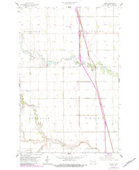
1963 Map of Kelso
USGS Topo · Published 1964About this map
The North Branch Elm River and South Branch Elm River meander through the central Traill County plains, defining the topography of this agricultural landscape. The survey captures the corridor of the Great Northern railroad as it parallels the highway system through the small settlements of Kelso and Alton. This era represents a period of infrastructure development by the State of North Dakota Water Commission under the direction of Governor William L. Guy and Chief Engineer Milo W. Hoisveen, evidenced by the presence of a Gaging Station and Pumping Sta along the riverbanks. Local history is anchored by the Bohnsack Cem and the surrounding townships of Bloomfield, Hillsboro, and Bohnsack. The map also identifies industrial sites like the Gravel Pits and recreational spaces such as the Roadside Park, providing a complete view of the rural economy and community life in the early 1960s.
Find a feature on this map
14 named features on this map. Tap any name to fly to it.
Don’t see what you’re looking for? This feature index may not catch every label — zoom into the map to look around manually.
Map Details
Editions of this 1963 Kelso Map
2 editions found
Other maps of this area

1918 · Kelso
USGS Topo · 1:62,500

1918 · Hendrum
USGS Topo · 1:62,500

1943 · Kelso
USGS Topo · 1:62,500

1952 · Grand Forks
USGS Topo · 1:250,000

1956 · Grand Forks
USGS Topo · 1:250,000

1963 · Gardner
USGS Topo · 1:24,000

1963 · Hillsboro
USGS Topo · 1:24,000

1963 · Halstad SW
USGS Topo · 1:24,000
1964 · Caledonia
USGS Topo · 1:24,000

1966 · Grand Forks
USGS Topo · 1:250,000