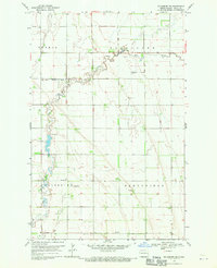
1968 Map of Galesburg SE
USGS Topo · Published 1970About this map
The Elm River meanders across the Red River Valley in this late 1960s study of Traill County, showing a landscape defined by industrial agriculture and early telecommunications. The survey detail highlights significant water management infrastructure, including the Augustadt Dam and the Elm River Diversion Drain, reflecting efforts to control the plains' drainage. This agricultural grid is punctuated by massive landmarks of the television era, specifically the Radio Tower (KTHI-TV) and Radio Tower (KXJB-TV), which were among the tallest structures in the world at the time of their construction. Local genealogy interests center on the southern portion of the map near the Galesburg township line, where the Stordahl Ch and an adjacent Cem represent the spiritual and community anchors of the surrounding rural townships of Norman, Blanchard, and Greenfield.
Find a feature on this map
13 named features on this map. Tap any name to fly to it.
Don’t see what you’re looking for? This feature index may not catch every label — zoom into the map to look around manually.
Map Details
Editions of this 1968 Galesburg SE Map
This is the sole edition of this map. No revisions or reprints were ever made.
Other maps of this area

1918 · Kelso
USGS Topo · 1:62,500

1943 · Kelso
USGS Topo · 1:62,500

1952 · Grand Forks
USGS Topo · 1:250,000

1956 · Grand Forks
USGS Topo · 1:250,000

1966 · Grand Forks
USGS Topo · 1:250,000

1966 · Galesburg
USGS Topo · 1:24,000

1967 · Mayville South
USGS Topo · 1:24,000

1967 · Ayr NE
USGS Topo · 1:24,000

1967 · Blanchard
USGS Topo · 1:24,000

1967 · Ayr NW
USGS Topo · 1:24,000