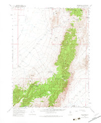
1961 Map of Fencemaker
USGS Topo · Published 1983About this map
Fencemaker Range and the Stillwater Range dominate this topographic study of the Nevada high desert, illustrating a landscape defined by isolated peaks and seasonal water sources. The map details the transition from the arid expanse of the Alkali Flat in Buena Vista Valley to the higher elevations of Logan Peak and Table Mountain. Significant for local history and resource extraction, the area includes the Gilberts Mine and various prospects, alongside infrastructure such as a Radio Facility and the Pleasant Valley Beacon. Settlement is sparse, represented by Fencemaker Camp and the Buena Vista Windmill. The network of travel is recorded through Kitten Springs Road and numerous unnamed jeep trails that navigate difficult terrain through McKinney Pass and Fencemaker Pass, connecting the valley floor to remote spring sites like Polkinghorne Spring and Kitten Springs.
Find a feature on this map
48 named features on this map. Tap any name to fly to it.
Don’t see what you’re looking for? This feature index may not catch every label — zoom into the map to look around manually.
Map Details
Editions of this 1961 Fencemaker Map
3 editions found

Other maps of this area

1908 · Carson Sink
USGS Topo · 1:250,000

1910 · Carson Sink
USGS Topo · 1:250,000

1931 · Lovelock
USGS Topo · 1:250,000

1932 · Sonoma Range
USGS Topo · 1:250,000

1935 · Lovelock
USGS Topo · 1:250,000

1939 · Sonoma Range
USGS Topo · 1:250,000

1954 · Unionville
USGS Topo · 1:62,500

1954 · Buffalo Mtn
USGS Topo · 1:62,500

1955 · Millett
USGS Topo · 1:250,000

1955 · Lovelock
USGS Topo · 1:250,000