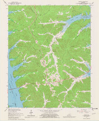
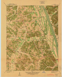
1967 Map of Fenton
USGS Topo · Published 1979About this map
The Land Between the Lakes occupies the central ridge of this landscape, a narrow peninsula defined by the Tennessee Valley Divide and flanked by the rising waters of Kentucky Lake and Barkley Lake. In the late 1960s, this area reflects the massive transition from a settled river valley to a national recreation area. The small communities of Fenton and Golden Pond remain visible along the primary east-west corridor of Highway 80 and Highway 68, with the latter featuring a Lookout Tower and Roadside Park. The Eggner Ferry Bridge provides a vital crossing over the broad expanse of the Tennessee River, while the surrounding terrain is deeply carved by countless inlets like Barnett Bay and Sugar Bay. Small family names and local geography are preserved in labels for Jenny Ridge and Mulberry Flat, marking the uplands before the valley floor was transformed.
Find a feature on this map
53 named features on this map. Tap any name to fly to it.
Don’t see what you’re looking for? This feature index may not catch every label — zoom into the map to look around manually.
Map Details
Editions of this 1967 Fenton Map
3 editions found
Other maps of this area

1936 · Mont
USGS Topo · 1:24,000

1936 · Fenton
USGS Topo · 1:24,000

1936 · Hiatt
USGS Topo · 1:24,000

1936 · Birmingham
USGS Topo · 1:24,000

1936 · Golden Pond
USGS Topo · 1:48,000

1936 · Rushing
USGS Topo · 1:24,000

1936 · Hico
USGS Topo · 1:24,000
1938 · Birmingham
USGS Topo · 1:24,000
1940 · Hiatt
USGS Topo · 1:24,000

1942 · Hico
USGS Topo · 1:24,000