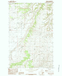
1985 Map of Fergus NE
USGS Topo · Published 1985About this map
Armells Creek and its seasonal tributaries define the landscape of this Central Montana region as it was documented in the late 1970s and early 1980s. The terrain is characterized by a complex network of drainages and coulees, reflecting a classic western ranching or grazing environment. The northern portion of the map is marked by the winding path of Murphy Coulee and Burned Timber Coulee, which flow toward the primary waterway. To the west, the watershed is shaped by Cottonwood Creek and its South Fork Cottonwood Creek. This 1985 provisional release, edited by the U.S. Geological Survey, provides a detailed record of the elevations and watercourses such as Dry Armells Creek before further modern land-use changes. The scarcity of named structures and settlements underscores the open, rural nature of this Fergus County territory during this era.
Find a feature on this map
6 named features on this map. Tap any name to fly to it.
Don’t see what you’re looking for? This feature index may not catch every label — zoom into the map to look around manually.
Map Details
Editions of this 1985 Fergus NE Map
This is the sole edition of this map. No revisions or reprints were ever made.
Other maps of this area

1943 · Landusky
USGS Topo · 1:125,000

1954 · Lewistown
USGS Topo · 1:250,000

1959 · Lewistown
USGS Topo · 1:250,000

1978 · Lewistown
USGS Topo · 1:100,000

1984 · Zortman
USGS Topo · 1:100,000

1985 · The Horse Ranch
USGS Topo · 1:24,000

1985 · Thompson Coulee
USGS Topo · 1:24,000

1985 · Fergus
USGS Topo · 1:24,000

1985 · Roy
USGS Topo · 1:24,000

1985 · Armells
USGS Topo · 1:24,000