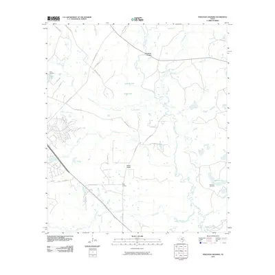
2010 Map of Ferguson Crossing
USGS Topo · Published 2010About this map
The Navasota River meanders through a landscape defined by its complex drainage network and rural settlements in the early 21st century. This area, located near the confluence of numerous water bodies, features the small community of Peach Creek and the historical location of Ferguson Crossing on the river. The map illustrates a transition in land use, where established rural sites like the Peach Creek Cemetery and Lamb Spring sit alongside newer residential developments indicated by suburban street layouts near Alum Creek. Large private water features, including Wichman Lake and Carter Lake, are supported by infrastructure such as the Wichman Lake Dam. The presence of several distinct creeks, such as Carters Creek, Lick Creek, and Gibbons Creek, reveals a heavily hydrated terrain that has historically shaped the agricultural and residential footprint of the region.
Find a feature on this map
43 named features on this map. Tap any name to fly to it.
Don’t see what you’re looking for? This feature index may not catch every label — zoom into the map to look around manually.
Map Details
Editions of this 2010 Ferguson Crossing Map
This is the sole edition of this map. No revisions or reprints were ever made.
Other maps of this area

1913 · Millican
USGS Topo · 1:31,680

1914 · Gay Hill
USGS Topo · 1:62,500

1914 · Navasota
USGS Topo · 1:62,500

1954 · Austin
USGS Topo · 1:250,000

1956 · Bryan
USGS Topo · 1:62,500

1956 · Carlos
USGS Topo · 1:62,500

1958 · Navasota
USGS Topo · 1:24,000

1959 · Millican
USGS Topo · 1:24,000

1959 · Clay
USGS Topo · 1:24,000

1959 · Reliance
USGS Topo · 1:24,000