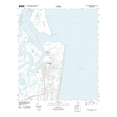
2011 Map of Fernandina Beach
USGS Topo · Published 2011About this map
Fernandina Beach serves as the central hub of this coastal survey, where the grid of the modern city meets the historic enclave of Old Fernandina. The landscape is defined by its complex maritime geography, including the northern tip of Amelia Island and the southern reaches of Cumberland Island across the St Marys Cumberland Island boundary. Cultural and industrial landmarks such as the Amelia Island Light and the Rayonier Fernandina Mill Wharf indicate a legacy of navigation and timber processing. This map documents a critical point in the Intercoastal Waterway, showing how natural features like Egans Creek and McClure Hill interface with protected spaces like Fort Clinch State Park. Farther north, the settlement of Dungeness and the sprawl of Tiger Island illustrate the transition between the developed Florida coast and the preserved Georgia shoreline.
Find a feature on this map
34 named features on this map. Tap any name to fly to it.
Don’t see what you’re looking for? This feature index may not catch every label — zoom into the map to look around manually.
Map Details
Editions of this 2011 Fernandina Beach Map
This is the sole edition of this map. No revisions or reprints were ever made.
Other maps of this area

1918 · St Marys
USGS Topo · 1:62,500

1918 · Cumberland Island
USGS Topo · 1:62,500

1918 · Kingsland
USGS Topo · 1:62,500

1919 · Fernandina
USGS Topo · 1:62,500

1919 · St Marys
USGS Topo · 1:62,500

1930 · Cumberland Island
USGS Topo · 1:62,500

1944 · Fernandina
USGS Topo · 1:62,500

1945 · Cumberland Island
USGS Topo · 1:62,500

1948 · Jacksonville
USGS Topo · 1:250,000

1957 · Jacksonville
USGS Topo · 1:250,000