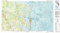
1981 Map of Fernandina Beach
USGS Topo · Published 1993About this map
Cumberland Island National Seashore and the surrounding coastal marshlands dominate this 1981 survey of the Florida-Georgia borderlands. The landscape is defined by the intricate waterways of the St Marys River and Satilla River, where the transition from inland timber and agricultural lands to the Atlantic coast is marked by significant maritime and military infrastructure. The presence of the Kings Bay Naval Base near Kingsland and the Jacksonville International Airport to the south illustrates the late 20th-century development of the region.
Find a feature on this map
105 named features on this map. Tap any name to fly to it.
Don’t see what you’re looking for? This feature index may not catch every label — zoom into the map to look around manually.
Map Details
Editions of this 1981 Fernandina Beach Map
3 editions found
Other maps of this area

1917 · Nahunta
USGS Topo · 1:62,500

1917 · Cambon
USGS Topo · 1:62,500

1917 · Boulogne
USGS Topo · 1:62,500

1917 · Macclenny
USGS Topo · 1:62,500

1917 · Hilliard
USGS Topo · 1:62,500

1918 · St Marys
USGS Topo · 1:62,500

1918 · Cumberland Island
USGS Topo · 1:62,500

1918 · Folkston
USGS Topo · 1:62,500

1918 · Moniac
USGS Topo · 1:62,500

1918 · Nahunta
USGS Topo · 1:62,500