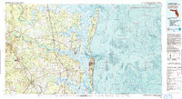
1981 Map of Fernandina Beach
USGS Topo · Published 1993About this map
Amelia Island and Cumberland Island dominate this coastal survey, where the intricate barrier island systems of Florida and Georgia meet. The map documents a complex landscape of maritime activity and conservation, featuring the Kings Bay Naval Base alongside the protected expanses of Cumberland Island National Seashore. The tidal economy is evident in the numerous bluffs and points along the Satilla River and St Marys River, such as Rose Bluff and Table Point, which have served as navigational landmarks for generations.
Find a feature on this map
113 named features on this map. Tap any name to fly to it.
Don’t see what you’re looking for? This feature index may not catch every label — zoom into the map to look around manually.
Map Details
Editions of this 1981 Fernandina Beach Map
3 editions found
Other maps of this area

1917 · Nahunta
USGS Topo · 1:62,500

1917 · Cambon
USGS Topo · 1:62,500

1917 · Boulogne
USGS Topo · 1:62,500

1917 · Macclenny
USGS Topo · 1:62,500

1917 · Hilliard
USGS Topo · 1:62,500

1918 · St Marys
USGS Topo · 1:62,500

1918 · Cumberland Island
USGS Topo · 1:62,500

1918 · Folkston
USGS Topo · 1:62,500

1918 · Moniac
USGS Topo · 1:62,500

1918 · Nahunta
USGS Topo · 1:62,500