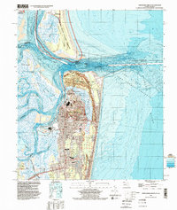
1994 Map of Fernandina Beach
USGS Topo · Published 2002About this map
Fernandina Beach serves as the focal point of this coastal landscape, situated on the northern end of Amelia Island. The map illustrates the town's grid and development near historic Old Fernandina, where landmarks like the Bosque Bello Cem and Nassau General Hospital are prominent. To the north, across the St Marys Entrance and the state boundary between Georgia and Florida, lies the southern tip of Cumberland Island, featuring the ruins of Dungeness and the protected lands of the Cumberland Island National Seashore.
Find a feature on this map
35 named features on this map. Tap any name to fly to it.
Don’t see what you’re looking for? This feature index may not catch every label — zoom into the map to look around manually.
Map Details
Editions of this 1994 Fernandina Beach Map
This is the sole edition of this map. No revisions or reprints were ever made.
Other maps of this area

1918 · St Marys
USGS Topo · 1:62,500

1918 · Cumberland Island
USGS Topo · 1:62,500

1918 · Kingsland
USGS Topo · 1:62,500

1919 · Fernandina
USGS Topo · 1:62,500

1919 · St Marys
USGS Topo · 1:62,500

1930 · Cumberland Island
USGS Topo · 1:62,500

1944 · Fernandina
USGS Topo · 1:62,500

1945 · Cumberland Island
USGS Topo · 1:62,500

1948 · Jacksonville
USGS Topo · 1:250,000

1957 · Jacksonville
USGS Topo · 1:250,000