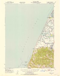
1951 Map of Ferndale
USGS Topo · Published 1953About this map
The complex delta of the Eel River and the northern reaches of Wildcat Ridge define this coastal landscape during the mid-century. This survey illustrates a network of sloughs, including McNulty Slough, Cannibal Slough, and Sevenmile Slough, which weave through islands and marshlands near South Bay. The dairy-rich bottomlands around Ferndale and Port Kenyon are well-represented, showing the distribution of family farms and local institutions like Fern Cottage.
Find a feature on this map
57 named features on this map. Tap any name to fly to it.
Don’t see what you’re looking for? This feature index may not catch every label — zoom into the map to look around manually.
Map Details
Editions of this 1951 Ferndale Map
2 editions found

Other maps of this area

1916 · Cape Fortunas
USGS Topo · 1:62,500

1919 · Glynn
USGS Topo · 1:62,500

1921 · Cape Mendocino
USGS Topo · 1:62,500

1922 · Eureka
USGS Topo · 1:62,500

1933 · Eureka
USGS Topo · 1:48,000

1942 · Eureka
USGS Topo · 1:62,500

1943 · Ferndale
USGS Topo · 1:62,500

1944 · Fortuna
USGS Topo · 1:62,500

1949 · Eureka
USGS Topo · 1:250,000

1950 · Cape Mendocino
USGS Topo · 1:62,500
Featured Places
- Ferndale, CA
- Port Kenyon, CA
- Arlynda Corners, CA
- Table Bluff Wiyot Reservation / giloulh, CA
- Humboldt County, CA