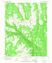
1966 Map of Ferron Canyon
USGS Topo · Published 1968About this map
Manti-La Sal National Forest lands dominate this mid-1960s survey, illustrating a landscape defined by high ridges and the intricate drainage of the Ferron Canyon system. The map records the infrastructure of high-altitude livestock grazing, most notably at the Horn Mtn Cow Camp and Dairy Point. These seasonal outposts were connected to the lower valleys by a network of primitive routes such as the Singleton Trail and the Dairy Trail (Pack), as well as a Jeep Trail traversing McEwan Flat.
Find a feature on this map
37 named features on this map. Tap any name to fly to it.
Don’t see what you’re looking for? This feature index may not catch every label — zoom into the map to look around manually.
Map Details
Editions of this 1966 Ferron Canyon Map
This is the sole edition of this map. No revisions or reprints were ever made.
Other maps of this area

1885 · Manti
USGS Topo · 1:250,000

1895 · Manti
USGS Topo · 1:250,000

1922 · Wasatch
USGS Topo · 1:31,680

1923 · Castle Dale
USGS Topo · 1:62,500

1923 · Hiawatha
USGS Topo · 1:62,500

1925 · Castle Dale
USGS Topo · 1:62,500

1925 · Hiawatha
USGS Topo · 1:62,500

1956 · Price
USGS Topo · 1:250,000

1960 · Price
USGS Topo · 1:250,000

1962 · Price
USGS Topo · 1:250,000