
1922 Map of Wasatch
USGS Topo · Published 1922About this map
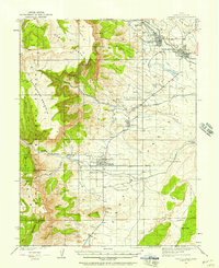
Manti National Forest encompasses most of this 1922 survey, illustrating the high-elevation divide between Sanpete and Emery County. The landscape is defined by massive peaks and high plateaus, notably Flagstaff Peak and Dry Mountain, which overlook the steep drainage of Wrigley Creek and Indian Creek. At this time, the area served primarily as summer grazing land, evidenced by the presence of the Larsen Ranch and Hansen Ranch located near the edge of Lower Joes Valley. The map, surveyed by W. B. Upton, Jr., provides a precise record of the natural topography and early livestock infrastructure before modern roads altered access to these high ridges. Local landmarks like The Pines, White Mtn, and Ferron Mountain are carefully delineated, marking the high-country points that guided early travelers and rangers through this part of the Wasatch Range.
Find a feature on this map
16 named features on this map. Tap any name to fly to it.
Don’t see what you’re looking for? This feature index may not catch every label — zoom into the map to look around manually.
Map Details
Editions of this 1922 Wasatch Map
This is the sole edition of this map. No revisions or reprints were ever made.
Other maps of this area

1885 · Manti
USGS Topo · 1:250,000

1885 · Fish Lake
USGS Topo · 1:250,000

1895 · Manti
USGS Topo · 1:250,000

1896 · Fish Lake
USGS Topo · 1:250,000
1923 · Castle Dale
USGS Topo · 1:62,500
1923 · Hiawatha
USGS Topo · 1:62,500
1925 · Castle Dale
USGS Topo · 1:62,500
1925 · Acord Lakes
USGS Topo · 1:62,500

1925 · Hiawatha
USGS Topo · 1:62,500

1956 · Salina
USGS Topo · 1:250,000