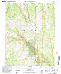
2001 Map of Ferron Canyon
USGS Topo · Published 2004About this map
Ferron Canyon dominates this high-altitude landscape where the Manti-La Sal National Forest meets the boundary between Sanpete and Emery counties. The map details a working mountain environment defined by seasonal livestock grazing and utility infrastructure, evidenced by the Horn Mtn Cow Camp and the Dairy Trail leading to Dairy Point. The rugged geography is further articulated by distinctive landmarks like The Kitchen and Steamboat Point, while water sources such as Lizard Lake and Bubs Meadow serve as critical points in an otherwise arid drainage system. The presence of the Singleton Flat Pipeline and a Gravel Pit near Ferron Mountain indicates the area's continued use for resource management and transport well into the late 20th century.
Find a feature on this map
35 named features on this map. Tap any name to fly to it.
Don’t see what you’re looking for? This feature index may not catch every label — zoom into the map to look around manually.
Map Details
Editions of this 2001 Ferron Canyon Map
This is the sole edition of this map. No revisions or reprints were ever made.
Other maps of this area

1885 · Manti
USGS Topo · 1:250,000

1895 · Manti
USGS Topo · 1:250,000

1922 · Wasatch
USGS Topo · 1:31,680

1923 · Castle Dale
USGS Topo · 1:62,500

1923 · Hiawatha
USGS Topo · 1:62,500

1925 · Castle Dale
USGS Topo · 1:62,500

1925 · Hiawatha
USGS Topo · 1:62,500

1956 · Price
USGS Topo · 1:250,000

1960 · Price
USGS Topo · 1:250,000

1962 · Price
USGS Topo · 1:250,000