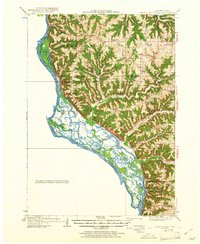
1929 Map of Ferryville
USGS Topo · Published 1961About this map
Ferryville and the riverfront settlements of the upper Mississippi River valley are captured here just before the era of major lock and dam construction. The landscape is defined by the complex network of backwaters like Winneshiek Slough and Henderson Slough, where the Chicago Burlington and Quincy railroad hugs the narrow terrace between the water and the bluffs. Inland, the map reveals a densely settled rural landscape of the 1920s, organized along high ridges such as Bishop Ridge and Rush Ridge. The abundance of local institutions, including the Parochial School, Freeman Church, and specialized facilities like the Upper Rush Creek School, points to a time when steep valleys like Cooley Valley necessitated numerous small, community-focused centers. This topography of deep hollows, such as Polander Hollow and Bohland Hollow, illustrates the driftless area's unique challenge to early road and rail transit.
Find a feature on this map
73 named features on this map. Tap any name to fly to it.
Don’t see what you’re looking for? This feature index may not catch every label — zoom into the map to look around manually.
Map Details
Editions of this 1929 Ferryville Map
2 editions found
Other maps of this area

1903 · Waukon
USGS Topo · 1:125,000

1923 · Viroqua
USGS Topo · 1:62,500

1924 · Gays Mills
USGS Topo · 1:62,500

1926 · Gays Mills
USGS Topo · 1:62,500

1926 · Stoddard
USGS Topo · 1:62,500

1926 · Viroqua
USGS Topo · 1:62,500

1926 · Wauzeka
USGS Topo · 1:62,500

1929 · Ferryville
USGS Topo · 1:62,500

1929 · Prairie Du Chien
USGS Topo · 1:62,500

1932 · Ferryville
USGS Topo · 1:62,500