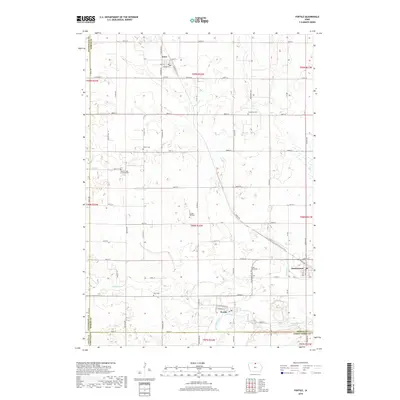
2018 Map of Fertile
USGS Topo · Published 2018About this map
Fertile, Iowa, and the surrounding agricultural landscapes of Worth County are documented here alongside the nearby communities of Joice and Hanlontown. The terrain is defined by the winding course of the Winnebago River in the south and the meandering paths of Beaver Cr and Winans Cr further north. This region is characterized by a dense network of rural roads organized on a grid, reflecting the systematic land survey patterns of the Midwest. Genealogists will find significant value in the distribution of several country burial grounds, including Beaver Creek Lutheran Cem, Concordia Cem, and Elim Cem, which serve as landmarks for the early farmstead families of the area. The map illustrates how these small rural centers developed along primary transport corridors, with the northern and southern town sites situated near essential water sources and regional thoroughfares like Co HWY s14 and Co RD a38.
Find a feature on this map
65 named features on this map. Tap any name to fly to it.
Don’t see what you’re looking for? This feature index may not catch every label — zoom into the map to look around manually.
Map Details
Editions of this 2018 Fertile Map
This is the sole edition of this map. No revisions or reprints were ever made.
Other maps of this area

1954 · Mason City
USGS Topo · 1:250,000

1957 · Mason City
USGS Topo · 1:250,000

1958 · Mason City
USGS Topo · 1:250,000

1972 · Clear Lake West
USGS Topo · 1:24,000

1972 · Fertile
USGS Topo · 1:24,000

1972 · Fertile NE
USGS Topo · 1:24,000
1972 · Clear Lake East
USGS Topo · 1:24,000

1972 · Bristol
USGS Topo · 1:24,000
1972 · Fertile SE
USGS Topo · 1:24,000

1972 · Pilot Knob
USGS Topo · 1:24,000