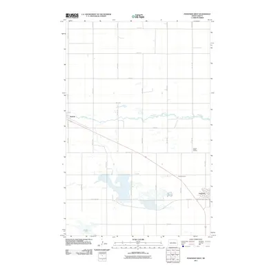
2011 Map of Fessenden West
USGS Topo · Published 2011About this map
Fessenden sits at the southeastern edge of this Wells County landscape, where the town's street grid, including 1st St N and 1st St S, meets the diagonal path of Old Hwy 52. The survey captures the quintessential North Dakota prairie section-line road system, dominated by a network of numbered avenues and streets that segment the agricultural plains. To the northwest, the small settlement of Manfred lies along the James River, which meanders through the central portion of the quadrangle. For those researching local genealogy or settlement patterns, the map identifies the German Baptist Cemetery and Hillside Cemetery, providing specific markers for early community burial sites. Significant water features like Hirshkorn Lake in the southwest and several unnamed prairie potholes punctuate the landscape, illustrating the region's natural drainage before it meets the river. This 2011 record documents the rural infrastructure of the area at the start of the 21st century.
Find a feature on this map
28 named features on this map. Tap any name to fly to it.
Don’t see what you’re looking for? This feature index may not catch every label — zoom into the map to look around manually.
Map Details
Editions of this 2011 Fessenden West Map
This is the sole edition of this map. No revisions or reprints were ever made.
Other maps of this area

1941 · Selz
USGS Topo · 1:62,500

1943 · Maddock
USGS Topo · 1:62,500

1945 · Maddock
USGS Topo · 1:62,500

1945 · Manfred
USGS Topo · 1:62,500

1948 · Fessenden
USGS Topo · 1:62,500

1948 · Manfred
USGS Topo · 1:62,500

1949 · Fessenden SW
USGS Topo · 1:24,000

1949 · Fessenden East
USGS Topo · 1:24,000

1949 · Emrick
USGS Topo · 1:24,000

1949 · Fessenden West
USGS Topo · 1:24,000