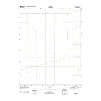
2010 Map of Feterita
USGS Topo · Published 2010About this map
Feterita stands as a focal point in this southwestern Kansas landscape, situated within a vast grid of section lines and agricultural expanses. The area is defined by its rectilinear road network, where routes like Rd T, Rd S, and Rd 6 divide the terrain into precise intervals characteristic of the Great Plains. A significant diagonal break in this geometry occurs with the passage of US Hwy 56, which cuts across the southern portion of the quadrangle. This thoroughfare serves as the primary regional connector, linking the small settlement area to the broader transportation corridor of the High Plains. The map's layout, punctuated by localized features such as Road N and Rd 11, reflects a highly organized rural infrastructure dedicated to farming and ranching at the start of the 21st century.
Find a feature on this map
10 named features on this map. Tap any name to fly to it.
Don’t see what you’re looking for? This feature index may not catch every label — zoom into the map to look around manually.
Map Details
Editions of this 2010 Feterita Map
This is the sole edition of this map. No revisions or reprints were ever made.
Other maps of this area

1955 · Dodge City
USGS Topo · 1:250,000

1958 · Dodge City
USGS Topo · 1:250,000

1959 · Dodge City
USGS Topo · 1:250,000

1973 · Rolla NE
USGS Topo · 1:24,000
1974 · Rolla SE
USGS Topo · 1:24,000
1974 · Hugoton SE
USGS Topo · 1:24,000

1974 · Hugoton
USGS Topo · 1:24,000

1974 · Feterita
USGS Topo · 1:24,000
1974 · Hugoton SW
USGS Topo · 1:24,000

1974 · Shore Airport SE
USGS Topo · 1:24,000