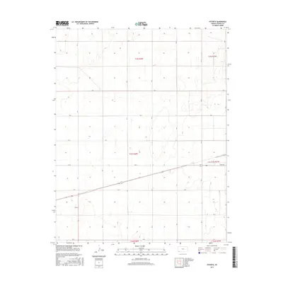
2015 Map of Feterita
USGS Topo · Published 2015About this map
The high plains of Stevens County are defined by a rhythmic, mile-by-mile grid of section roads that crisscross this agricultural landscape. At the center of this rural network lies Feterita, a small community situated at the intersection of several local corridors. The map documents the precise arrangement of the Public Land Survey System, illustrating township lines such as t33s r38w and t34s r38w that organized Western settlement. While much of the terrain is dedicated to open fields, the inclusion of named routes like Baker Ave and 10th St near the eastern edge provides specific touchpoints for local historians and genealogists tracing family landholdings. This 2015 survey serves as a clear record of the modern rural infrastructure, showing how traditional section roads like Rd K and Rd T continue to facilitate life and commerce in this corner of the state.
Find a feature on this map
24 named features on this map. Tap any name to fly to it.
Don’t see what you’re looking for? This feature index may not catch every label — zoom into the map to look around manually.
Map Details
Editions of this 2015 Feterita Map
This is the sole edition of this map. No revisions or reprints were ever made.
Other maps of this area

1955 · Dodge City
USGS Topo · 1:250,000

1958 · Dodge City
USGS Topo · 1:250,000

1959 · Dodge City
USGS Topo · 1:250,000

1973 · Rolla NE
USGS Topo · 1:24,000
1974 · Rolla SE
USGS Topo · 1:24,000
1974 · Hugoton SE
USGS Topo · 1:24,000

1974 · Hugoton
USGS Topo · 1:24,000

1974 · Feterita
USGS Topo · 1:24,000
1974 · Hugoton SW
USGS Topo · 1:24,000

1974 · Shore Airport SE
USGS Topo · 1:24,000