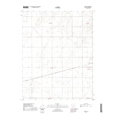
2018 Map of Feterita
USGS Topo · Published 2018About this map
The high plains of Stevens County are centered around Feterita, a settlement situated along the intersection of local routes and the diagonal traverse of Highway 56. This 2018 survey documents a landscape of precise geometric organization, defined by the Public Land Survey System grids including t33s r38w and t34s r38w. The terrain is marked by the expansive reach of the rural road network, with numbered and lettered corridors like Road N and Rd M facilitating movement across the agricultural expanse. The presence of numerous depression features across the quadrangle suggests the unique local hydrology and wind-sculpted topography characteristic of this portion of southwest Kansas. These natural features contrast with the rigid infrastructure of the county, where thoroughfares such as Rd 9 and 10th St provide structure to the sparsely populated landscape.
Find a feature on this map
27 named features on this map. Tap any name to fly to it.
Don’t see what you’re looking for? This feature index may not catch every label — zoom into the map to look around manually.
Map Details
Editions of this 2018 Feterita Map
This is the sole edition of this map. No revisions or reprints were ever made.
Other maps of this area

1955 · Dodge City
USGS Topo · 1:250,000

1958 · Dodge City
USGS Topo · 1:250,000

1959 · Dodge City
USGS Topo · 1:250,000

1973 · Rolla NE
USGS Topo · 1:24,000
1974 · Rolla SE
USGS Topo · 1:24,000
1974 · Hugoton SE
USGS Topo · 1:24,000

1974 · Hugoton
USGS Topo · 1:24,000

1974 · Feterita
USGS Topo · 1:24,000
1974 · Hugoton SW
USGS Topo · 1:24,000

1974 · Shore Airport SE
USGS Topo · 1:24,000