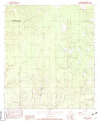
1982 Map of Fields
USGS Topo · Published 1983About this map
Beauregard Old River Game and Fish Preserve dominates the northwestern portion of this Beauregard Parish landscape, highlighting a region defined by its complex drainage network and low-lying topography. The small community of Fields serves as a central landmark, notable for the presence of Hyatt High Sch, which anchors the local area. The terrain is intricately etched by numerous waterways, including Windham Creek, Indian Creek, and Bear Head Creek, alongside several named drainage features like Paul Burns Gully and White Oak Gully. These labels suggest a landscape historically shaped by water management and natural runoff patterns.
Find a feature on this map
18 named features on this map. Tap any name to fly to it.
Don’t see what you’re looking for? This feature index may not catch every label — zoom into the map to look around manually.
Map Details
Editions of this 1982 Fields Map
This is the sole edition of this map. No revisions or reprints were ever made.
Other maps of this area

1935 · Wilson Lake
USGS Topo · 1:31,680

1947 · Singer
USGS Topo · 1:31,680

1947 · Carter Creek
USGS Topo · 1:31,680

1947 · DeQuincy
USGS Topo · 1:31,680

1947 · Oretta
USGS Topo · 1:31,680

1947 · Wilson Lake
USGS Topo · 1:31,680

1947 · Hyatt
USGS Topo · 1:31,680

1947 · Bivens
USGS Topo · 1:31,680

1947 · Long Marsh
USGS Topo · 1:31,680

1949 · Bancroft
USGS Topo · 1:31,680