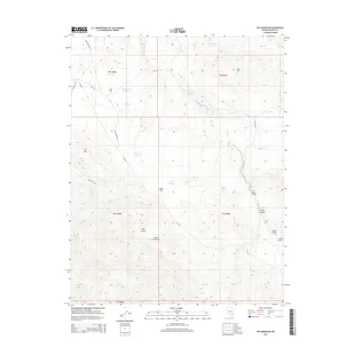
2014 Map of Fife Mountain
USGS Topo · Published 2014About this map
The high desert landscape of Fife Mtn and the northern reaches of the Clover Mountains dominate this 2014 survey of Lincoln County. This area is defined by its seasonal water sources and livestock management infrastructure, shown through a series of isolated catchments like Fife Flat Reservoir, Cedar Reservoir, and the Mag Reservoir. These reservoirs, scattered across high plains such as Fife Flat and Sheep Flat, reflect the ranching history of the Great Basin where water is the primary driver of movement and activity. Beyond the basins, the terrain is cut by numerous drainages including Jacks Canyon, Tanks Canyon, and Pine Canyon. Natural water sources like Fife Spring and Grapevine Spring provide reliable points for local researchers and genealogists tracing historical movement along rural routes like Stoker Flats Rd and Barns Canyon Rd, which navigate the elevation changes between Gum Hill and the deep canyons to the south.
Find a feature on this map
32 named features on this map. Tap any name to fly to it.
Don’t see what you’re looking for? This feature index may not catch every label — zoom into the map to look around manually.
Map Details
Editions of this 2014 Fife Mountain Map
This is the sole edition of this map. No revisions or reprints were ever made.
Other maps of this area

1885 · Pioche
USGS Topo · 1:250,000

1886 · Pioche
USGS Topo · 1:250,000

1954 · Caliente
USGS Topo · 1:250,000

1959 · Caliente
USGS Topo · 1:250,000
1972 · Acoma
USGS Topo · 1:24,000
1972 · Eccles
USGS Topo · 1:24,000
1972 · Islen
USGS Topo · 1:24,000

1973 · Ella Mountain
USGS Topo · 1:24,000
1973 · Leith
USGS Topo · 1:24,000
1973 · Jacks Mountain
USGS Topo · 1:24,000