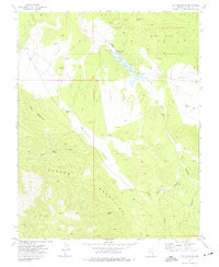
1973 Map of Fife Mountain
USGS Topo · Published 1977About this map
The Clover Mountains dominate this high-desert landscape in Lincoln County, where water management is the primary marker of human presence. Published from a 1973 field check, the map reveals a network of high-elevation catchment systems, including Three Points Reservoir, Cedar Reservoir, and Pine Canyon Reservoir, which features a gaging station and dam. The terrain is characterized by broad alluvial features like Fife Flat and Sheep Flat, interspersed with steep canyons such as Jacks Canyon. Scattered infrastructure like a quarry and numerous corrals suggest the area was utilized for both mineral extraction and livestock ranging. Springs like Fife Spring and Grapevine Spring provide vital natural water points amidst the dry washes of Gum Hill.
Find a feature on this map
45 named features on this map. Tap any name to fly to it.
Don’t see what you’re looking for? This feature index may not catch every label — zoom into the map to look around manually.
Map Details
Editions of this 1973 Fife Mountain Map
This is the sole edition of this map. No revisions or reprints were ever made.
Other maps of this area

1885 · Pioche
USGS Topo · 1:250,000

1886 · Pioche
USGS Topo · 1:250,000

1954 · Caliente
USGS Topo · 1:250,000

1959 · Caliente
USGS Topo · 1:250,000
1972 · Acoma
USGS Topo · 1:24,000
1972 · Eccles
USGS Topo · 1:24,000
1972 · Islen
USGS Topo · 1:24,000

1973 · Ella Mountain
USGS Topo · 1:24,000
1973 · Leith
USGS Topo · 1:24,000
1973 · Jacks Mountain
USGS Topo · 1:24,000