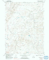
1968 Map of Fiftymile Flat
USGS Topo · Published 1991About this map
Fiftymile Flat characterizes this high-plains landscape in Natrona County, where the intricate drainages of the South Fork Powder River meet an extensive network of ephemeral creeks and draws. Surveyed in the late 1960s, the map reveals a remote ranching environment defined by isolated landmarks like the Powder River Corrals and specialized sites such as Jack Ellis Camp. The presence of these named camps and corrals suggests the seasonal movement of livestock across this dry terrain, supported by man-made water sources like the Blue Hill Reservoir and Three T Reservoir.
Find a feature on this map
22 named features on this map. Tap any name to fly to it.
Don’t see what you’re looking for? This feature index may not catch every label — zoom into the map to look around manually.
Map Details
Editions of this 1968 Fiftymile Flat Map
2 editions found
Other maps of this area

1955 · Arminto
USGS Topo · 1:250,000

1958 · Arminto
USGS Topo · 1:250,000

1962 · Arminto
USGS Topo · 1:250,000

1968 · Willow Creek School
USGS Topo · 1:24,000

1968 · Merino
USGS Topo · 1:24,000

1968 · Camel Hump Reservoir
USGS Topo · 1:24,000

1968 · Reynolds Reservoir
USGS Topo · 1:24,000

1968 · Big Sulfur Draw
USGS Topo · 1:24,000

1968 · Fiftymile Flat
USGS Topo · 1:24,000
1968 · Anderson Draw
USGS Topo · 1:24,000